Aerial Archaeology and Landscape Archaeology
Aerial Archaeology is one of the most efficient methods of prospection. Both vertical and oblique aerial photos are used for interpretation. Above all, repetitive observations conducted over a period of several years - if possible, in different seasons - draw new details again and again from the soil. These can be joined, like pieces of a puzzle, into an extensive overall view of an archaeological landscape.
This can be best demonstrated using the results of a project along the river Leitha, some 30 km souteast of Vienna. The aim was to demonstrate the value of aerial archaeology both to detect and document archaeological sites in a mainly arable region and to provide detailed mapping of all relevant archaeological structures and features within that area. Between 2003 and 2005 several reconnaissance flights (altogether 35 hours) were carried out. Through a contract with an Austrian military air base we have free access to all of their vertical photographs made using a Zeiss RMK with a format of 23 by 23 cm. Their scales range between 1: 30.000 and 1: 5.000, but a scale of about 1: 8.000 is preferred and mostly available. More than 2.000 vertical aerial photographs, made by the Austrian air force in Langenlebarn, were archaeologically interpreted.
As a result, more than 640 archaeological sites were identified, many of them multi-period settlements or graveyards. This means that within only 35 flying hours the total inventory of archaeological sites had been doubled. Altogether, a detailed archaeological map of the 600km2 area could be created. During this procedure, more than 30.000 individual archaeological features (pits, houses, graves etc.) and landscape features (mostly old river channels, ditches, and drains) were mapped. The resulting data was used as a basis to show the spatial distribution of the individual archaeological phases and to analyze in detail the late iron-age and Roman settlement patterns.
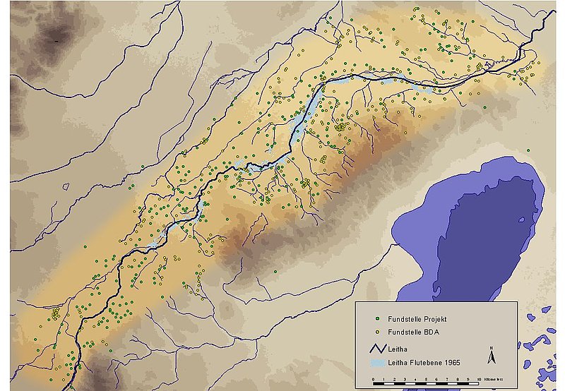
Map of archaeological sites: green dots refer to sites detected from aerial archaeology
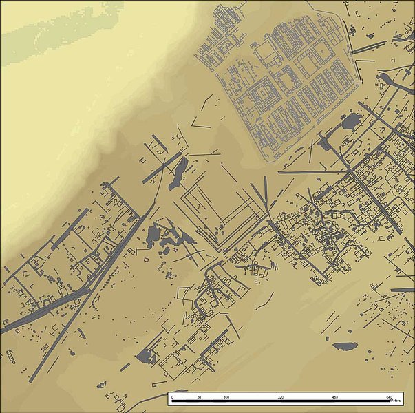
Detail of the Roman city of Carnuntum. All of the black structures were mapped from aerial photographs.
This clearly demonstrates one important advantage of applying aerial archaeology in landscape projects: Besides an efficient way to detect sites, it can give you detailed knowledge on the structures of a site. Thisd can be clearly seen in the example of Roman Carnuntum.
What seems to be additionally important is that using aerial archaeology, one can get hold of structures, often invisibel to field surveys: graveyards, field systems, or palaeoenvironmental structures (terraces, palaeorivers).

Frohsdorf: the graveyard from the 8th century AD could only be found using aerial archaeology. A field survey did not yield any artefacts that would lead to the detection of this site.
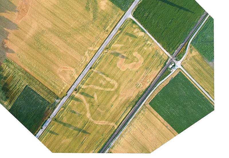
Palaeoriver.

Mapping of the palaeorives in the area of the river Leitha.