How Do Archaeological Sites Show
Aerial archaeologically speaking, there are two different types of sites:
- Sites which are still more or less cut into the soil or rise above it, like preserverd banks and ditches of former enclosures, tumuli, ancient roads, field systems, stone quarries etc. They can be in most cases seen by their light-and-shadow contrast. That is why they are called "shadow marked" sites.
- Sites that have been levelled completely (mostly) by agriculture. They are still leaving traces at the surface, which are only visible under certain conditions. According to these traces, they can show up (among others) as "soil marked" and as "crop marked" sites.
Shadow-marked Sites
They can be seen more or less easily depending on several factors like preserved height, color and vegetation of the objects, and time, date, flying height, angle of view and direction of view while you are photographing them.
Almost flat sites need very slanting sunlight to produce a visible shadow. Therefore, the flying time should be early morning or late evening.
A determining factor for the visibility of a shadow marked site is the orientation of linear features towards the sunrays. If they are at right angles, they will throw distinct shadows. If the alignment is more parallel, the shadows will be weak and hard to discern.
Best results are obtained, when photographing shadow marked sites against the sunlight. At this view, shadows will not be hidden by the objects themselves. Nevertheless, this view is problematical, because dust is most effective with it. Therefore, weather conditions should be at an optimum, when photographing shadows.
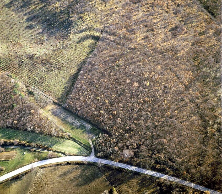
In our main working area, most of the shadow marked sites are under trees, posing special problems. If the trees are deciduous, these sites are best recorded in winter. With conifers, it is probably better to return to surveying techniques on the ground. Shadow marked sites can be photographed at any time of the year.

Rectangular entrenchment of the Slavic period.

The tree covered site can be seen from the air only during Winter time.
Soil-marked Sites
When a ditch or a pit is dug, the local soil-profile gets disturbed. In most cases, the refilled material is different from the undisturbed soil. The differences are twofold:
First, the material itself is different. Refilled material is in most cases not so compact, and it contains more humous components, making it look darker.
Secondly, the grain size distribution differs from the undisturbed soil. Refillings have mostly a larger number of smaller grain sizes.
Both cases lead to a better water-storage, which makes the refillment look darker than the surrounding soil, which can be seen very well from a higher viewpoint.
The opposite happens in cases of buried walls. Here, the compact stones and mortar cannot store any water, and so, the soil gets very easily dry. Additionally, stones and mortar are brought to the daylight by ploughing, which all together makes buried walls look brighter, than the surrounding area.
Soil marked sites are mostly recorded during spring or autumn, after ploughing. They can be photographed also under light cloud cover.
The different refillment has especially at the beginning and at the end of winter another effect, which is known as "frost marks" or "snow marks". Refilled ditches and walls are storing warmth or cold. Therefore, they can get visible as differential thawing and freezing of hoar frost or a light snow cover. They can be recorded in the morning, but they are visible just during a few hours timespan.
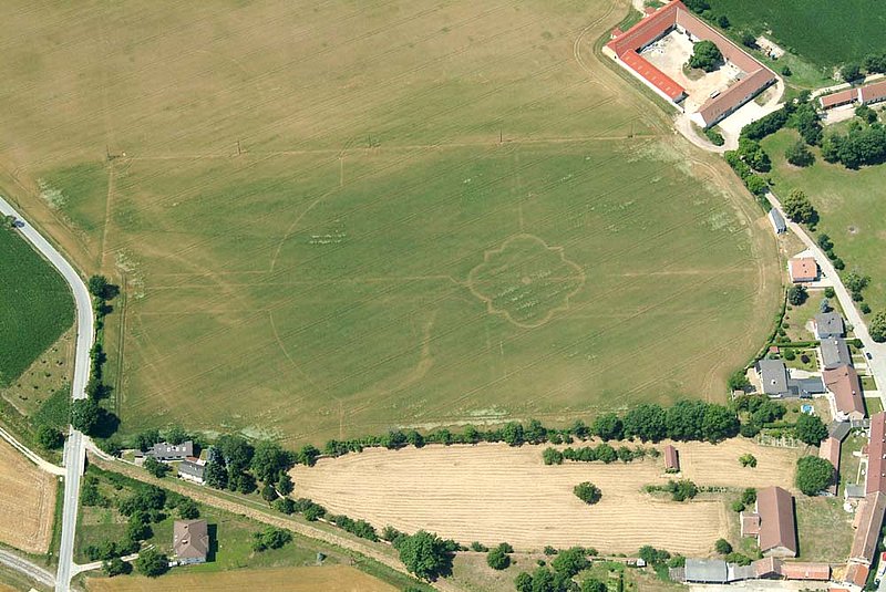
"Positive" soil marks showing a middle Neolithic circular ditch system (Hornsburg).

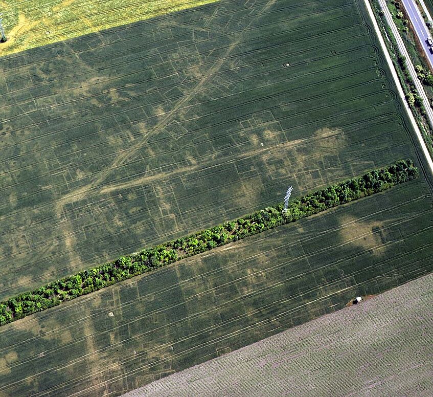
"Negative" soil marks revealing roads and buildings of Roman Carnuntum.
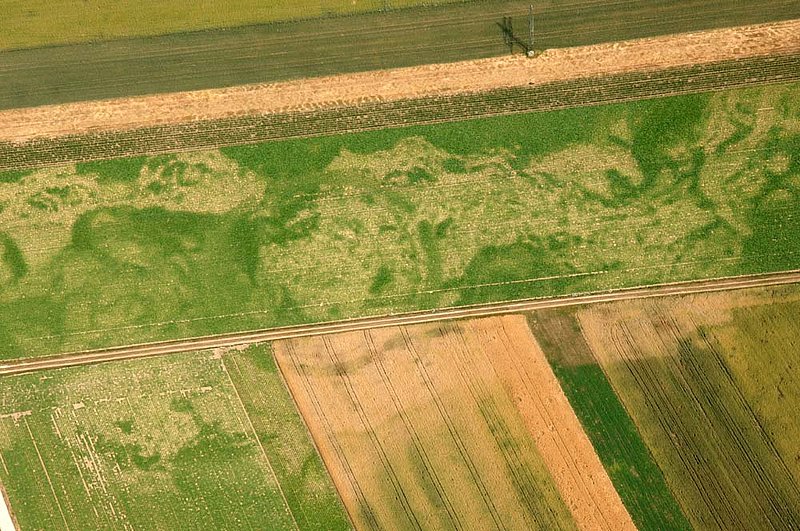
Crop-marked Sites
Cropmarks (or better: vegetation marks) are an indirect effect of buried archaeological features. Their visibility depends on soil, climate and vegetation.
During a dry summer, the water content of the soil vanishes, and the plants would need more water, than is available. There is a so called Soil Moisture Deficit (SMD). Plants are reacting differently on a SMD. Some start to whither, others grow at a lower level. But mostly, they try to bury their roots deeper, to get eventually more water from lower soil levels. Since the refillments of archaeological features mostly can store more water, the plants growing over them will have more water resource. This will make them grow higher and ripen later than the plants around them ("positive marks").
Positive crop marks can be seen from the air (and also from the ground) in two ways. The plants over them will stay green for a longer period and will have a darker green, producing a tonal contrast. Additionally, these plants will grow higher. Usually the height difference is not too big, but it is enough to throw a shadow in slanting sunlight.
As you can imagine, the opposite will take place with plants over buried walls: plants will run out of water soon; they will ripen earlier and stay shorter ("negative marks").
Almost any crop can develop marks, if conditions are well. Cereals, as wheat and barley, are especially suitable. They are reacting fast on a SMD and, what´s also important, they are growing very close, which provides us with highly detailed marks. You can compare this to the resolution of your screen, where wheat and barley would correspond to VGA, maize to EGA beets to CGA and so on.
Crop marked sites are mostly recorded from May to July. If it is dry, winter crop can develop marks already during early spring.
Baroque garden as negative cropmarks
Circular ditch in sugarbeet
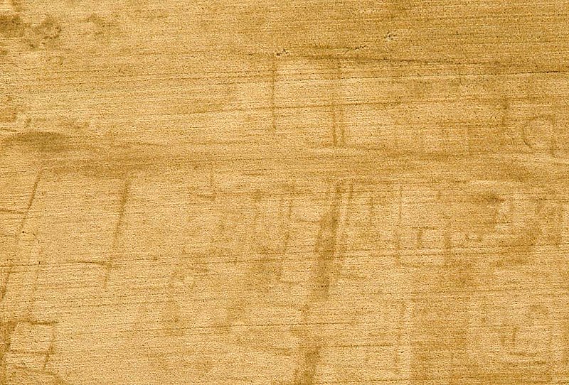
Negative cropmarks showing Roman buildings in Carnuntum.