Brief History of Austrian Aerial Archaeology
Aerial archaeology is an old prospection technique. The first attempts, to use the distant view for archaeological purposes were already made during the last century. There are only a few aerial photographs from the early times. Among these are recordings of the Forum Romanum from 1899 and Stonehendge (what else would you expect?) from 1906. These early air-photos were made out of balloons.
More systematic recordings were done during World War I, when German military aviators - instructed by Theodor Wiegand - photographed ruined towns and cities in Sinai. In these years, airplanes were used the first time with aerial archaeology.
In the 1920s, aerial archaeology got a theoretical background. Two persons are to be mentioned here: O.G.S. Crawford in England and P.A. Poidebard in Syria. Crawford is said to be the inventor of scientific aerial archaeology. In March 1923, he gave a lecture to the Royal Geographical Society, where he showed aerial views of the "Celtic fields", old soil marked field boundaries at Windmill Hill, which he had photographed during 1922. In 1924, he made the first archaeological flying season over Wessex, producing several black and white plates of a very high quality.
When the Viennese amateur archaeologist J. Czech von Czechenherz learned about Crawford's results in 1924, he immediately decided to take a flight in the area of the Vienna (Windischbauer, 1994). While in other countries military resources could be used for aerial archaeology Austria was not allowed to maintain an air force by the peace treaty of St. Germain. Therefore, he had to find other resources, which he could use for his flying and chartered a scheduled aircraft of a transport company, flying between Vienna in Munich. Using this Junkers, the searched and photographed already known sites around Vienna - "Napoleonschanze", the "Gemeindeberg bei Ober-St. Veit", the "Satzberg", and the "Leopoldsberg". He made 16 photographs (Czech, 1924), which unfortunately are missing today. E. Nischer Falkenhof did the first archaeological mapping of aerial photographs in Austria. In 1931, the "Bundesamt für Eich- und Vermessungswesen" made vertical photographs of the "Braunsberg" near Hainburg for him. Drawing directly from the photographs, he mapped the ramparts of the hillfort (Mitscha-Mährheim, 1950) and produced a base map for his subsequent excavations (Nischer-Falkenhof and Mitscha-Mährheim, 1932).
In 1933, the dentist F. Hautmann, the later co-founder of the County Museum of Burgenland, started to make reconnaissance flights using a friends sports plane. He was taking photographs of prehistoric and archaeological sites in the areas of Mattersburg, Draßburg, Eisenstadt, Krensdorf, Großhöflein, Steinbrunn and Wiener Neustadt (Kaus, 1990).
Since 1935 Austria was allowed to maintain an Air Force again. E. Swoboda, who was member of the flying corps during World War I, was now able to use the military resources and made photographs of the Roman ruins of Carnuntum several times in the late 1930s. After the Anschluss in 1938, he even managed the German Luftwaffe to do reconnaissance flights (Harl, 1992).
World War II made an end to these first scanty attempts in Austrian aerial archaeology. In 1955, the year of the Austrian State Treaty, Austria became his air sovereignty back. A few years later, in 1961, a section for aerial archaeology was founded by G. Spitzer within the Austrian Society for Pre- and Protohistory. His aim was to help his colleagues with the acquisition of aerial photographs and to do some scientific work in aerial archaeology (Friesinger, 1969). In the same year contacts to the military air base in Langenlebarn were made (Bohly, 1982), which later led to a written agreement. One of the first archaeological sites photographed during this time was the middle Neolithic circular ditch system (Kreisgrabenanlage=KGA) of Kamegg, documented on the 6th of October. A few years later, H. Friesinger became head of the section. As he had served in the military air bases of Zeltweg and Langenlebarn, he was able to intensify the contacts and many vertical and oblique photographs were made. Until 1969 some 400 shots of different archaeologically interesting areas were taken.
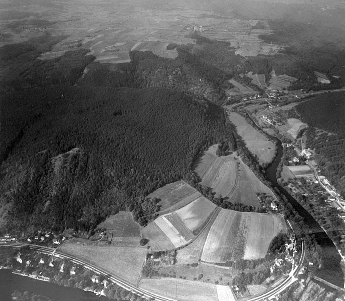
One of the first aerial photographs produced for the new section for aerial archaeology. It shows the middle Neolithic circular ditch system of Kamegg. © bmlvs/luaufklsta
In the 1970s also other colleagues started to do aerial reconnaissance flights. Maybe most successful was the geographer L. Beckel photographing many sites for Austrian archaeologists. His photographs are of high-quality and found entry in many publications (Vorbeck and Beckel, 1973; Beckel, 1981; Beckel and Harl, 1983). They are also used as basis for the city map of the Roman town Virunum (Harl, 1992). Between 1978 and 1984 a project to map ancient Carnuntum was supported by the Austrian Science Fund. Its aim was to produce a map at the scale of 1:2.000 of all traces visible in aerial photographs made by the archaeologists M. Kandler and W. Jobst covering the whole area of Carnuntum. The rectification of the photographs was done in close cooperation with the Viennese Institute for Photogrammetry and Remote Sensing (Jobst et al., 1983; Pauli, 1983; Schedivy, 1986; Waldhäusl and Kraus, 1985). However, due to a lack of budget the work was not continued.
In 1978, H. Friesinger became ordinary Professor at the Institute for Pre- and Protohistory in Vienna. He began lecturing aerial archaeology and started to extend the section for aerial archaeology, which meanwhile had become part of the Institute, the "Aerial Archive". It was equipped with an analog Zoom Transfer Scope for mapping photographs. Additionally, it was enlarged by the negatives of some 20.000 aerial photographs made made the Austrian military during the 1960s. The inventory was made by R. Nikitsch, who was a freelance worker at the Aerial Archive between 1979 and 1991 (Universitätsdirektion Wien, 1981).
During the very dry spring in 1981, it seemed reasonable to make a vertical documentation of large parts of the Weinviertel between the "Manhartsberg" and Vienna at the scale of 1:10.000. During March, 2000 km2 were documented on 1200 photographs (Doneus, 1997). The results were exceptional and led to a pilot-project in cooperation with the Department for Archaeology of the Federal Bureau on Historical Monuments to establish a cadastre of archaeological sites.The Viennese Institute for Photogrammetry and Remote Sensing was also interested in this idea and a few theses were submitted (Grün, 1982; Jiresch, 1983; Muggenhuber, 1982; Platzer, 1982; Rabl, 1983; Reinisch, 1982). The project was not continued due to financial problems. Another result of the 1981-photographs was an exhibition on aerial archaeology, called "Fenster zur Urzeit - Luftbildarchäologie in Niederösterreich", which took place one year later at the museum for prehistory in Asparn/Zaya (Fenster zur Urzeit, 1982). Between the 1st of April and 31th of October at about 40.000 visitors were counted. Thereafter the exhibition was shown around Austria and Germany (Bregenz, Münster, Braunschweig, Stift Altenburg).
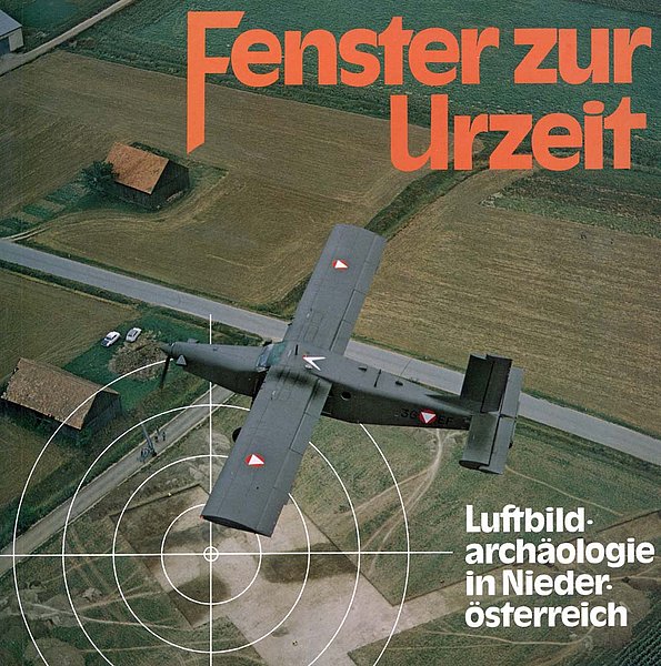
Cover image of the exhibition "Fenster zur Urzeit"
Between 1985 to 1990 the research project "Neue Wege der Frühgeschichtsforschung" was supported by the Austrian Science Fund. The aim of the research project was the interdisciplinary documentation of the settlement history in the valley of the river Kamp. Among the applied methods, aerial archaeology became the most important technique within this project. An increasing number of reconnaissance flights was undertaken by the aerial archaeologists themselves. A digital database was set up to archive the growing stock of aerial photographs as well as the known archaeological sites (Nikitsch, 1989) and focus was put on mapping of aerial photographs. The cooperation with the Viennese Institute for Photogrammetry and Remote Sensing made it possible to use modern photogrammetrical equipment for the interpretative mapping of aerial photographs but also for terrestrial applications (Nikitsch, 1987; 1990).
The Institute for Pre- and Protohistory in Innsbruck started in1985/86 to do aerial reconnaissance flights. The project, which was initialised by A. Lippert, lasted for two seasons. Within this time, O. Braasch surveyed the Inntal between Kufstein and Telfs and the terraces of the Mittelgebirge and detected 42 archaeological sites (Lippert, 1989). In the second half of the Eighties this cooperation led to several lectures of O. Braasch at the institutes for Pre- and Protohistory and Classical Archaeology in Innsbruck (Braasch 1992).
During winter 1987/88, the Institute for Pre- and Protohistory in Vienna moved to a new building in the 19th district. In the course of reopening and restructuring the Institute got an analytic plotter DSR14 for the analysis of vertical aerial photographs. This instrument is still in use.
To help our colleagues in former Czechoslovakia to get started with aerial archaeology, the Institute for Pre- and Protohistory in Vienna organised a training school in 1990, which was financed by funds of the Austrian Ministry of Science. Since 1992 M. Doneus continued the earlier work and systematically developed further all fields of aerial archaeology (production and archive in the aerial photographs, photogrammetrical analysis, integrated interpretation). The foundation of the Vienna Institute for Archaeological Science (VIAS former called IDEA) in 1994 was an important step as aerial archaeology (V. Holzer and since 1996 G. Scharrer) and geophysical prospection (W. Neubauer) were installed as part of VIAS. This departments of VIAS are also located at the Institute for Pre- and Protohistory in Vienna. This enables us to work in very close cooperation in the “Vienna Prospection Archive” especially on the combination of different prospection data (Doneus and Neubauer, 1998).